
Photo by Prakoso Composed by D. K. R. Ranoem

Never treated as a threat & distress.
Mount Merapi is a volcano in the central part of Java Island and one of the most active volcanoes in Indonesia. Mount Merapi is a popular climbing object because of its real charm and grandeur. The topography of the Merapi area varies beautifully, from gentle to hilly and mountainous. The forest area around the peak is also the Mount Merapi National Park area with its function as a protected forest, nature reserve and natural tourism park. The forest on Mount Merapi has been designated as a protected area since 1931 to protect water sources, rivers and support living systems around the city. Mount Merapi has many water sources due to the pressure of water vapor from within the earth. There are many flows which then form canyons on the slopes and then form sedimentary plains of volcanic material. These rivers supply water to the surrounding area. Apart from rivers, there are also water sources which are used as bathing places and sources for irrigating rice fields.

Mount Merapi, peak height 2,930 meters above sea level.


Villages are a vital part that cannot be separated in the hierarchical structure of the state. There would be no country without having the smallest parts which in the context of the Indonesian state are usually called villages. Indonesia was originally a local community that had territorial boundaries, was inhabited by a number of people, and had customs for managing its own region. The village and its government have experienced developments and ups and downs from time to time until now.
The village is the most basic authority in the government system. Villages have autonomy in building and running their own government. A village is a legal community unit that has territorial boundaries that has the authority to regulate and manage government affairs, the interests of local communities based on community initiatives, original rights or traditional rights that are recognized and respected in the State government system.
Rural Communities
‘The concept of development in villages is a priority in development, so that villages and their communities can develop and be independent and can face various development challenges. The touch of village development continues to be carried out in an effort to empower villages and their communities.’
Human resources have great potential to help accelerate the process of improving the economy of village communities. All efforts to improve the economy will not be separated from human resources in the village as the main actor. Building human resources is very important for the state government to achieve significant improvements in the economy of village communities. Care is needed in observing the lives of village communities to discover their great potential in the fields of special skills, handicraft products, tourist attractions, agricultural products and culinary riches.

Mount Merbabu 57 square kilometres.
‘Sleeping mountain’
Geographically, Mount Merbabu is located in three districts in Central Java, namely Boyolali, Semarang and Magelang. Known as a strato type volcano, cone-shaped and has layers of lava and ash. Even though it is known as a sleeping mountain, Mount Merbabu actually has five craters with exotic panoramas with a uniquely scenic attraction. The topography is mostly hilly, in several locations there are ravines and very steep cliffs. Mount Merbabu erupted in 1560 and 1797. The mountain is quite popular among climbers. The terrain is not too tough. However, climbers must pay attention to potential dangers arising from cold air, thick fog, dense forests and lack of water sources.


— Negara Kesatuan Republik Indonesia Gemah Ripah Loh Jinawi —
‘Somewhat soft but strong’
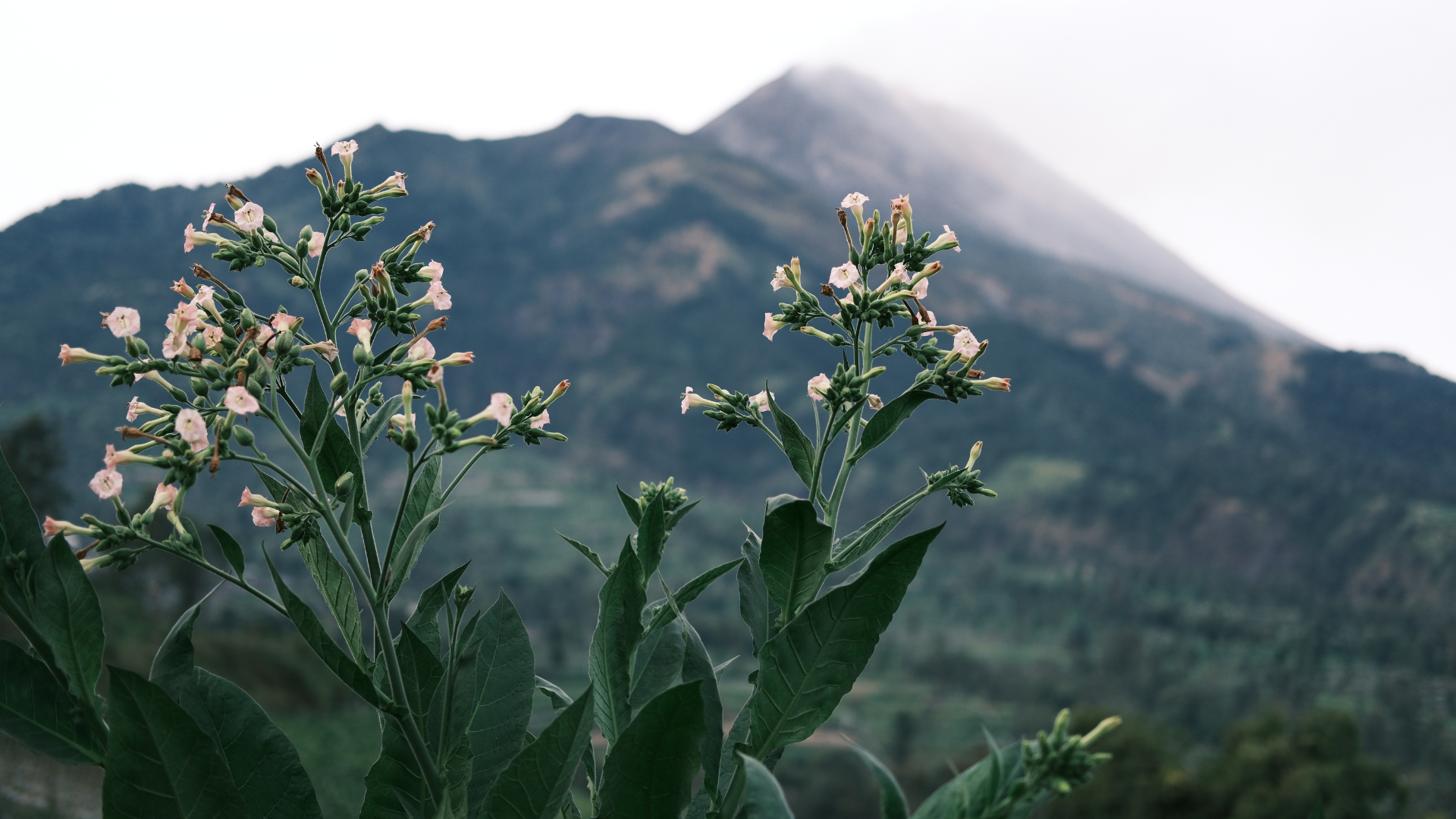
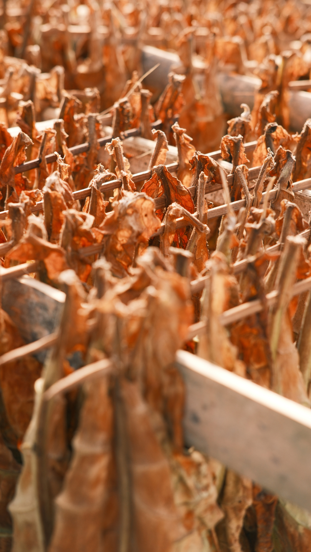
The only use of tobacco is the part of the leaves that is used as raw material for cigarettes and cigars. Tobacco is a seasonal agricultural product which is not a food commodity, but rather a plantation commodity. This product is consumed not for food but as a pastime or "entertainment". Tobacco can also be chewed. The rich content of secondary metabolites also makes it useful as a pesticide and medicinal raw material. Tobacco is a product that is very sensitive to cultivation methods, planting location, season, weather, and post-harvest processing methods. A tobacco cultivar will not produce the same quality if planted in a different agroecosystem. Tobacco products are very specific to a particular region and a particular cultivar. As a result, various tobacco products are usually named after the location where they are grown. Tobacco is able to grow in large areas with a growing time of 60 to 90 days with frost-free conditions from the day of grafting to harvest with a temperature of 20 °C to 30 °C. The dry season is the time to harvest and ripen the leaves to obtain good quality leaves. The harvested leaves will have thin and light leaves when there is excessive rain.

Mount Merapi, peak height 2,930 meters above sea level.


Life supporter & fertility maintainer.
Mount Merapi is one of the most active volcanoes in Indonesia, so the peak is never overgrown with vegetation due to high activity. The types of plants at the top are alpine types typical of the Javanese mountains. Volcanic activity provides fertility to the land on the slopes of Merapi. The vomit material from the Merapi eruption contains many nutrients, especially phosphorus and potassium. The fertility of the Merapi region is used by the people of the slopes of Merapi to grow various commodities, including horticulture, fruit, coffee and tobacco. During the rainy season, the slopes of Mount Merapi are very fertile and planted with horticultural crops such as cabbage, broccoli and tomatoes. Meanwhile, during the dry season, farmers simultaneously plant tobacco to optimize agricultural land production throughout the year.

Farmers on the slopes of Mount Merapi harvest vegetables & package them for immediate transport.


Wisdom of natural resources
Java is an island that was largely formed from volcanic activity. A series of volcanic mountains form a range that stretches from east to west of this island, with river alluvial sediment plains in the north. The island of Java, which is very fertile and has high rainfall, allows the development of rice cultivation in wetlands. Almost the entire region of Java has been affected by volcanic activity. There is a mountain range that stretches from east to west of this island, all of which at certain times have been active volcanoes. The highest volcano in Java is Mount Semeru, while the most active volcanoes in Java and even in Indonesia are Mount Merapi and Mount Kelud. Mountains and plateaus that are far apart are relatively isolated and suitable for wetland rice fields. Rice paddy fields in Java are one of the most fertile in the world.

Mount Merbabu peak height 3,145 meters above sea level.


Coexist with the mountain
The slopes of Mount Merapi are a water catchment area which functions to ensure the availability of water on the slopes of Merapi. The three river basins that receive abundant water from the Merapi area. A river basin is an area bordered by mountain ridges and functions as a reservoir for rainwater to be channeled through small rivers to the main river. Each river basin is a unitary ecosystem area that is formed naturally, rainwater seeps or flows through the branches of the river. The upstream part of the river basin is a water catchment area whose role is to store water for the survival of living creatures. The catchment area is the area upstream of a river that supplies water to the river. A river is understood as a system of water flow, starting from springs to estuaries where the flow is limited by boundary lines. Maintained river basins are able to protect water supplies, keep the land fertile, and protect the surrounding forest areas. By making efforts to protect river watersheds, more healthy water will be available for the survival of living creatures. Livestock in river basin environments are healthier and nearby farms or plantations can provide better harvests.

Mount Merapi, peak height 2,930 meters above sea level.
Vegetation Landscape Vibrancy
Mount Merapi's volcanic activity provides fertility for the land on the slopes of Merapi. The material vomit from the Merapi eruption contains many nutrients, especially phosphorus and potassium. The fertility of the Merapi region is used by the people of the slopes of Merapi to grow various commodities, for example horticulture, fruit, coffee and tobacco. Fertile soil is an important factor in the quality of the plants that grow on it. Indicators that influence it include humidity levels, light intensity, balance of acidity levels and nutritional levels. Soil fertility also refers to the soil's ability to encourage plant production and growth processes. Including material for organisms that can grow in it. Fertile soil has balanced components including water elements, microorganisms, organic matter and nutrients that can be obtained from fertilizer or similar.
Mount Merapi, peak height 2,930 meters above sea level.

Mount Sumbing & Sindoro peak height 3,371 and 3,153 meters above sea level.
‘Once Lost a City’ Sublimity Concatenation.
The location of Mount Sumbing and Mount Sindoro are facing each other. Together with Mount Sindoro, Mount Sumbing forms a twin mountain landscape, such as Mount Merapi and Mount Merbabu. The height is not much different and the natural conditions of the mountain are also almost the same. However, for climbers, Mount Sumbing has a more difficult track due to the steep gradient and longer route. Most of the mountain slopes have been used for agricultural land. Mount Sumbing is the third highest mountain on the island of Java after Mount Semeru and Mount Slamet. The last eruption was recorded in 1730, which formed a lava dome with lava flowing towards the lowest crater rim. Increased activity of Mount Sumbing was observed with increased seismic and visual activity, especially Deep Volcanic and Shallow Volcanic Earthquakes.


Mount Merbabu peak height 3,145 meters above sea level.

Mount Merapi, peak height 2,930 meters above sea level.
Maintain mutual harmony
Mount Merapi's volcanic activity provides fertility for the land on the slopes of Merapi. The material vomit from the Merapi eruption contains many nutrients, especially phosphorus and potassium. The fertility of the Merapi region is used by the people of the slopes of Merapi to grow various commodities, for example horticulture, fruit, coffee and tobacco. Fertile soil is an important factor in the quality of the plants that grow on it. Indicators that influence it include humidity levels, light intensity, balance of acidity levels and nutritional levels. Soil fertility also refers to the soil's ability to encourage plant production and growth processes. Including material for organisms that can grow in it. Fertile soil has balanced components including water elements, microorganisms, organic matter and nutrients that can be obtained from fertilizer or similar.

— Negara Kesatuan Republik Indonesia Gemah Ripah Loh Jinawi —


Mount Merapi, peak height 2,930 meters above sea level.


Unity in independent sustainability
The plateau is a flat area with a height of more than 700 meters above sea level. Indonesia has many highlands with diverse characteristics and natural resources. The highlands have their own advantages in the fields of plantations and agriculture, very good for planting various plants because it has fertile soil. Farmers in highland areas grow many crops in the form of vegetables and fruit. In addition to fertile soil, the plateau has an abundance of fresh water. The plateau contains about half of all fresh water used by humans. This is because mountains intercept air flow, raise it upwards, and cause it to condense, turning into clouds so that rainfall in highland areas is quite high. Therefore, fresh water supplies are so abundant. This plantations and highland agriculture produce a source of food for the community to avoid hunger, as well as a source of income to maintain community welfare. At the same time, it also ensures the availability of employment opportunities for the community.

— Negara Kesatuan Republik Indonesia Gemah Ripah Loh Jinawi —


The end of planting field
Tobacco plants are planted at the end of the rainy season and harvested at the peak of the dry season. After three months the tobacco can be harvested. Tobacco leaves are harvested every 2 days by picking 2 or 3 leaves of the plant that are already yellow. If it rains, the tobacco leaves will turn light green again. The harvest is immediately taken home to be ground using a grinding machine. The tobacco is ground, then dried under the hot sun using a wooden base with holes so that the heat can be absorbed thoroughly. The drying process takes two or three days. The dried tobacco is put and collected into sacks to be sold to large tobacco warehouses.


— Negara Kesatuan Republik Indonesia Gemah Ripah Loh Jinawi —


Tobacco products are very specific to a particular region and a particular cultivar.


‘Turn in the reverse direction’
The tobacco plant is thought to have entered the Indonesian archipelago in the 16th century. Tobacco commodities in Indonesia are always faced with dilemmatic situations and controversy regarding their role in the national economy and their impact on health. On the one hand, these commodities provide the livelihood of tens of millions of farmers in Indonesia and contribute to state and regional government revenues, on the other hand these commodities have a negative impact on public health. The tobacco processing industry has an important role in driving the national economy. Tobacco plants have become a primary need in daily consumption for some people.

— Negara Kesatuan Republik Indonesia Gemah Ripah Loh Jinawi —


— Negara Kesatuan Republik Indonesia Gemah Ripah Loh Jinawi —


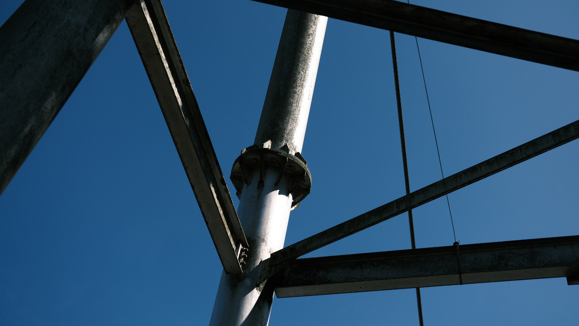
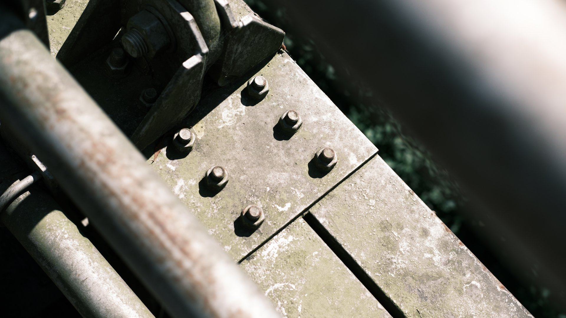
Connecting life for society
Bridges are one of the infrastructures in an area. The function of bridges for society is very important. The activities of people around will be disrupted if any damage occurs to the bridge. Bridges play a role as access and facilities for various community economic activities. Generally, bridges are created because there are roads that are interrupted by valleys, seas, highways, straits and trains. Bridges can connect villages or cities as a means of connectivity in communication and economic activities. Boyolali Regency, has a suspension bridge, built in 2012 after the 2010 eruption, to function as an evacuation route if at any time an eruption of Mount Merapi occurs. Passed by motorcyclists and pedestrians, connects two hamlets at the foot of the slopes of Mount Merapi and Mount Merbabu, the suspension bridge has vital value and is a tourism destination that is quite refreshing for the local economy. The view from this suspension bridge is right in the valley between Mount Merapi and Mount Merbabu. Visitors to the bridge can see the charm and majesty of Mount Merapi when facing south. Meanwhile, visitors can see the panorama and wisdom of Mount Merbabu when facing north.

— Negara Kesatuan Republik Indonesia Gemah Ripah Loh Jinawi —